Photos: https://www.flickr.com/photos/brijsman/albums/72157672226531915
The loop “with all the toppings”
We did a variation of the classic loop around Mt Hood hike which I call the Mt Hood Loop “with all the toppings”. We added all the major side trips (McNeil Point, Yocum Ridge, and Cooper Spur) and camped near the top of each of them. Also, whereas most people start at Timberline Lodge and hike clockwise, we opted to start at Cloud Cap saddle and hike counter clockwise. This allowed us to get the infamous Elliot Creek crossing out of the way right at the very start of the hike.
Speaking of river crossings, the Elliot Creek crossing is just the first of many on this loop, some of which are not much easier than Elliot. Most hikers opt for dry river crossing by hopping across boulders or tree trunks. If you choose to do so, hiking poles are essential. For this particular hike, we think wet river crossings by wading through the water are safer. In that case, a pair of river crossing shoes (light sneakers or sandals) are needed unless you don’t mind hiking in wet boots. Attempting to cross the rivers barefoot is not safe.
Day 1: Cloud Cap trailhead to McNeil Point
We started our hike on Sunday morning to avoid the worst of the weekend crowds and parked in the parking lot for the camping ground at Cloud Cap saddle. The parking, payment, and registration situation is a bit confusing here. You do not need to pay any camping or day use fee at the payment station which is right next to the road. You only need an Oregon Forest Pass or National Park pass to park here (you need to get these in advance, you cannot get them here). You do need to self-register for a back country permit at the registration station which is at the trail-head towards the back of the camping ground.
When starting off from Cloud Cap camping, take the left (East) trail and not the right (West) trail which is marked closed. Almost immediately you come to another split. Here take the right (West) trail which is marked Elk Cove. Soon the trail starts braiding and becomes confusing; I suspect all the trails end up at the same place in the end. If you go up and to the right (West) you will soon end up on the top of the East Moraine with Elliot Creek roaring far below you. Follow the clear path down to the creek. There used to be ropes here, but they were torn off when we got there. No matter – you don’t need them, the path is easy enough on this (East) side. We went several hundred feet upstream and found a safe wet crossing spot just below the big boulder where Elliot forks. Once on the other (West) side, we went up the shelf and found the ropes to take us up the West moraines. The slope is much steeper here and the ropes are definitely helpful. Once you reach the top of the moraines, you want to take a not-so-obvious right down into the forest, not the much-more-obvious trail that goes over the top of the ridge towards the Elliot Glacier (which turned out the be quite scenic — we accidentally followed it for quite some time). Soon after you return to the main Timberline trail, where someone posted a sign “DON’T DO IT”, and someone else wrote instructions on how to do it right below it.
For most of the rest of the day, the trail meanders through forests and flower choked meadows with occasional glimpses of the snow-capped Mt Hood Summit far above. In the next 7.6 miles you pass several trail splits for the Elk Cove trail, the Pinnacle Ridge trail, the Vista Ridge trail, and the Eden Park Trail. After another 0.4 miles, soon after passing a stone shelter, you reach the marked turn-off for the official 1.3 mile trail to McNeil point — the first of our three side trips. Supposedly there is also a more difficult unmarked scramble which we did not see. For the first mile or so, the trail goes up through forests and meadows. Fill up when you cross a small creek, this will be your last drinking water. Eventually, the trail emerges out of the tree line at the McNeil Point Shelter. A few hundred yards above the shelter, on the ridge there is a great camping site. If you continue a bit further and climb the steep section onto the ridge there are two or three even better camping sites. All of these camping sites are dry (i.e. they don’t have drinking water, you need to carry it in.) We used the first of these as the camping site for the first night. The view from these camping sites is simply amazing. You are perched right on top of the ridge, with a deep valley spread out below you, and a river cascading down from wide ice expanses of Sandy Glacier on Mt Hood which looms above you. This is what backcountry hiking is all about.
The trail continues up the ridge to the actual McNeil Point at the end of the trail. This is a viewpoint at a large rock from where you have magnificent views the the Glisan and Sandy Glaciers on either side of the ridge. There is a tiny little (dry) campsite here as well.
Distance: 8.9 miles.
Day 2: McNeil Point to Yocum Ridge
After the glorious first night, we returned on the McNeil trail back to the Timberline trail. For the next 8.4 miles the Timberline trail takes you through forests on a long loop over a ridge and then down into the Sandy River valley, and then up again until you eventually reach the turn-off for the Yocum Ridge trail. Along the way there is a marked short-cut which shaves off a bit of distance. There were plenty of blue berries along this section which slowed progress as I could not resist munching on them.
The Yocum ridge was our second side-trip. It is a long 3.5 mile slog through the forest, and you only get a pay-off at the very end. But what a pay-off it is: once again you find yourself on top of a ridge, looking down into a deep valley below, and a Glacier (this time the Reid Glacier) spreading out before you on Mt Hood above. This is where we set up camp for the second night. The trail actually continues for another half mile or so, over the ridge, to some nice camp sites on the other side. However, since we had already seen that valley from our McNeil Point campsite, we stayed on the Reid Glacier side of the ridge.
The camp site was a dry one, i.e. no drinking water. We saw only two places for drinking water on the entire Yocum Ridge trail. The first is about halfway clearly visible on the left of the trail, which is a small frog-filled lake with not-so-good somewhat putrid water. Maybe 10 to 15 minutes later you pass some camp spaces, and if you stand still and listen carefully here, you will hear (but not see) a small stream nearby. This stream has good drinking water.
Distance: 12.9 miles (21.8 miles cumulative)
Day 3: Yocum Ridge to White River
Overnight the temperature had plummeted. We had dinner at 38 degrees Celsius, and we had breakfast at 5 degrees Celsius. Clouds were rolling in over the ridge and most of the day would be overcast and chilly. We did not mind that much because most of the day would take us through forest, and the absence of heat would allow us to make good distance.
First, we retraced our steps back down the Yocum Ridge trail, and after another 0.7 miles we reached the pretty and deservedly popular Remona Falls. Some trail descriptions advise detouring around this section of trail because of dangerous erosion, but we did not notice anything of the kind. After another half mile, you are back on the Timberline Trail, on a steady ascent through more forests. After 3.2 miles you reach the optional detour over Paradise Park Loop. This loop provides a welcome break from the forests through high alpine meadows.
After the loop, back on the Timberline trail, it’s another 3.0 miles up through forest before you finally reach the Timberline Lodge. Another nice thing about starting at Cloud Cap is that you get to have a beer at the bar of the Timberline Lodge halfway through the hike!
With slightly wobbly feet from the beers, we continued the hike around 5pm, for another 1.3 miles on the Timberline trail which coincides with the Pacific Crest Trail (PCT) for this section. We met several PCT thru-hikers on their way from Mexico to Canada, many of them almost giddy with excitement at the prospect of all-you-can-eat buffets at the Timberline Lodge. It is amazing what tiny backpacks the PCT’ers carry. It seems that the longer the hike, the smaller the backpack.
We put up camp on the ridge above White River, just before the split where the Timberline splits off again from the PCT. It was still heavily overcast and the winds were strong, so for the first time on the trip we put the fly on the tent and camped behind the protection of some trees. Once again, the camp site was dry, There is no water anywhere on the ridge (we had filled up at the lodge).
Distance: 14.8 miles (36.6 miles cumulative)
Day 4: White River to Cooper Spur
We woke up to bright sunshine, packed up and worked our way down into wide rocky Gorge and crossed both arms of the White River. Cairns and an obvious path led to the entry point to the trail on the far side.
After an initial steepish ascent through forest, we exited the wilderness and entered the Mount Hood Meadows ski area where the sight of ski lifts and parking lots (both empty this time of year) brings you back into the “civilized world”. On the plus side, when the ski slopes are not covered with snow, they are beautiful flower-filled meadows.
After about 3 miles of this, you cross the Clark River, a ridge, and then one of the bigger river crossings across the Newton Creek.
From here you go up the intimidatingly named Gnarly Ridge, which brings you into what I thought was the most beautiful part of the Mt Hood Loop proper (not including side trips). You now enter the high country, working your way up above tree line to above 7000 feet. As you are above tree line, you have unobstructed views of Mt Hood with its glaciers close by above, the river filled gorges below, and views of the fruit fields of Hood River and neighboring mountains in the distance.
Along the way through the high country, you cross ten or so snow fields. We had brought micro-spikes which provided extra security, but you don’t really need them.
After 4.2 miles through the high country, we reached the shelter at the bottom of Cooper Spur, which was our last and most amazing side-trip.
While the Cooper Spur is not very long (only 1.8 miles) it goes up relentlessly and towards the end steeply, from 6600 feet to 8450 feet. There is no water anywhere at the shelter, nor on the Cooper Spur trail, nor at the camping site at the top of the spur (although you can melt snow there). Come prepared with lots of water. The last water we saw was a small stream in the high country one or two miles before the shelter.
Some hikers coming down from the Cooper Spur told us that there was an amazing campsite well before the top, so we set off with our full backpacks intent on camping there. We worked our way up the long lazy switch-backs in the beginning. Once the switch-backs were blocked by snow, we continued our way up the much shorter, steeper, and rougher (but still perfectly doable and safe) switchbacks on the ridge towards to top of the trail before the saddle. There, after one hour and forty minutes of climbing, we finally reached the camp site. There were a couple of campsites with high rock wind breaks, and there was one magical campsite in the middle of thin air right on the ridge of the saddle. Not knowing what the winds were going to do, we opted for the camp site with the wind breaks. Later that night another couple arrived and picked the site on the ridge.
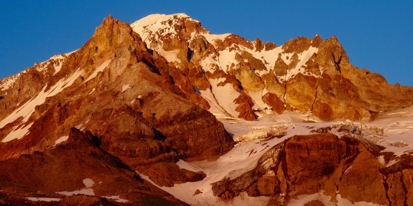
This was the most magical camping site of the entire trip. You sit on a ridge on top of a saddle with views in all directions. No longer were you looking up at the glaciers far above. No, here you are looking down at the glaciers below you in all directions. They tumble down Mt Hood, breaking into huge chunks of ice with deep crevasses that you can look into from your vantage point. Whatever pain you have to go through to haul your packs and water up, it is definitely worth it. You have gone as far up as you can go on hiking trails. From here on it is mountaineering. The top of Mt Hood appears to be right there within grasping distance, although in reality it is still another 3000 feet up.
Distance: 12.6 miles (49.2 miles cumulative)
Day 5: Cooper Spur to Cloud Cap trailhead
We woke up at a chilly sun rise. Mt Hood and the glaciers were even more magical in the morning light coming in from the East. We had breakfast on the ridge, and climbed up the saddle to the edge of the snow. After spending another hour or so there, taking in the views, we made the 1.8 miles back down the Cooper Spur, and then the easy 1.0 mile back to the parking lot. We got into the car, stopped at Hood River for ice creams and drove over to Cougar on our way to the next hike around Mt St Helens.
Distance: 2.8 miles (52 miles cumulative)
