
When talking about multi-day hiking in Greenland, the first thing that comes to mind is the Arctic Circle Trail. But did you know that there are endless multi-day hiking opportunities in South Greenland as well? If you Google it, you will mostly find the relatively easy sheep farm to sheep farm walks over dirt roads. While these are certainly nice hikes, there is so much more to explore! If you take your tent into the back country a wild and rugged landscape awaits, varying from gentle rolling green hills dotted with lakes to steep ice covered mountains surrounded by glaciers to challenging bogs and swaps and nearly impenetrable bushes.
In late May to mid June of 2025, the two of us (Bruno and Tecla) spent eighteen days trekking in South Greenland with our tent.
In those eighteen days we did not meet a single soul, except when we passed by a town or farm.
Five treks in South Greenland
We did five different treks, varying from easy day hikes to tough multi-day treks, which we will soon describe in detail in follow-up blog posts:
- A seven-day trek in the Qassiarsuk area. This is a very enjoyable and relatively easy trek visiting some of the sheep farms and exploring the exquisitely beautiful lake-dotted hills where the sheep graze. The first day was over a dirt road and the remaining six days were mostly off-trail. The trail was relatively easy over low grassy hills without many bogs or bushes, except for the second day which was a bit more challenging (we later found out an easier option may exist). We spent two nights in a cozy cabin at Tasiusaq sheep farm and the remaining four nights in our tent.
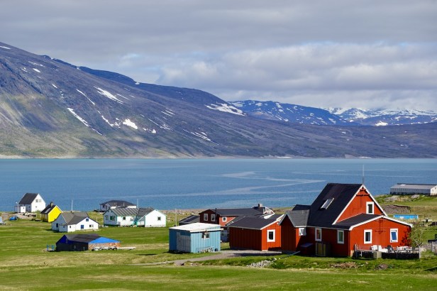
- Two day-hikes in the Igaliku area. Igaliku is a quintessentially picturesque Greenlandic small village with colorful houses and sheep farms. It is pleasure to spend a few days here soaking up the atmosphere, doing the beautiful easy day hikes, and enjoying the luxury hotel and fine cuisine.
- A four-day trek in the Narsarsuaq area. It is very worthwhile to extend the classic hike to the glacier viewpoints with a couple of extra days to explore the rugged high plateau behind Narsarsuaq. Link to blog post for this trek.
- A five-day trek from Itilleq or Igaliku to Qaqortoq. We extended the classic Igaliku to Qaqortoq trek with an extra day for two side-trips: Nuuluk mountain and Sissarluttoq world heritage site. The trail is mostly straightforward and easy, except for the half-day section starting at Hvalsey church and lasting about (rough guess) 10 kilometers until you reach the last flat section to Qaqortoq. Because the trail has not been maintained, this is now a hellishly difficult bush-wack through shoulder-high bushes and stony boggy steep terrain. Unless you have exceptionally strong stamina, we now recommend doing the trail North-bound to Igaliku, skipping the difficult part by taking a boat to Hvalsey church.
- A three-day trek in the area West of Qaqortoq. We extended the popular trail that goes around the big lake next to Qaqortoq to continue to the coast on west side of the peninsula. We followed three different valleys: two were beautiful and pleasant, one was a mosquito-infested bog. We also did a side-trail towards the cave on the way back.
Beyond these five treks, the possibilities in South Greenland are nearly boundless. Where else can you step out of the airport building and walk into the wilderness within a few minutes? We have heard rumors of a nice trek from Qaqortok to Alluitsup Paa. But since most of the hiking is off-trail anyway, you are only limited by your imagination and your stamina.
Difficulty
The two day hikes as well as the farm-to-farm gravel roads described in the blogs are easy and suitable for any fit person.

The multi-day hikes, on the other hand, are for the most part very remote and rugged.


In many places there is no trail whatsoever. In a few places there is a trail, sometimes clear but often very faint. If you are on a trail and you find yourself having lost the trail (a frequent occurrence) it is worthwhile to spend some effort trying to relocate the trail because it usually so much easier walking on-trail than off-trail.
In areas where sheep graze, what appears to be a trail is usually just a sheep track rather than a hiking trail. While they make the walking easier, they will eventually veer off into the wrong direction, so keep an eye on your map and don’t zone out blindly following the sheep track.
In terms of markings, there may be an occasional cairn or faded red dot, but they are few and far between. There are large sections without any markings at all.

Much of the walking is over rolling hills with short sheep-grazed grass on firm ground. This is very easy and enjoyable hiking.

But there are challenging sections as well.
Some sections have dense birch bushes. If they are only ankle-high, they are easy enough to walk over. Sometimes there are large boulders mixed in with bush overgrowth, hiding deep holes. Sometimes the bushes are waist-high or even shoulder-high and very dense. Fighting through these bushes can be a slow and tiring bush-whacking nightmare.

Other sections are extremely boggy or marshy, your feet sinking into the very soft wobbly moss, making it a challenge to keep your balance and your feet dry. And you are never sure how deep you will sink.
Steepness is not a problem and no serious scrambles are involved.
Having said all of that, we experienced some hard work but no particular technical challenges. We thoroughly enjoyed the vast majority of the trek.
By mid June the mosquitos come out. It varies a lot how bad they are from place to place. In marshy boggy areas they are the worst and can take on biblical plague proportions. You must bring a mosquito net to cover your head if you want to maintain your sanity. Mid May to mid June as well as late August to September are great hiking seasons to avoid to mosquitos.
Navigation
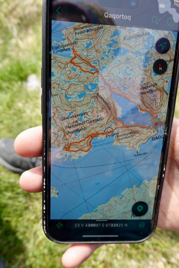
You need to be completely self-sufficient and you need to be very confident navigating off-trail using a phone app and a map as backup.
We like the the following phone apps:
- Gaia is very easy to use and detailed.
- OsmAnd is a bit more powerful but also more difficult to use.
- We also often use Wikiloc to find and download the route other people hiked in case there is no trail. Note that this doesn’t mean there is a trail or even that it is a good route. It only means that some person did it and recorded it.
- Avenza Maps is popular with the locals. This is essentially a paper map (see “Greenland be a pioneer” maps below) projected on your phone screen with a dot for your current location. You have to purchase the offline maps for between $5 and $10 per map. The maps are not particularly accurate, but they have routes that Gaia and OsmAnd don’t have.
Make sure you use the paid version of these apps (not the free version) so that you can download maps and trails for offline use. There is no phone signal on most of the hikes.
Also make sure you only use the app when you really need it to conserve battery and also bring a powerbank for longer hikes.
We used the following paper maps as backup and also because they contained routes that were not shown on Gaia or OsmAnd:
- Arctic Sub map Narsarsuaq (Qassiarsuk – Igaliku). ISBN 978-87-992925-0-9. We purchased this map at cafe Thorhildur in Qassiarsuk (which is run by Elna from Sillisit sheep farm).
- The “Greenland be a Pioneer” series of maps, 1 : 100,000 scale. We were able to purchase these in the Blue Ice Explorer offices.
- Map “Narsaq” ISBN 87-90677-05-6
- Map “Qaqortoq” ISBN 87-90677-06-4
Note that the dotted lines on these maps are just “suggested routes”; there are no trails and no markers there. And while the dashed lines are supposed to be marked trails, many of these trails have not been maintained in years; on many sections both the markings and the trails themselves have long disappeared.
Communication
There is cell phone coverage on only about 10% of the trails. Sometimes you can catch a whiff of a signal from a moumtain top. We used Airalo eSIMs, which worked well, but were expensive: about $9 for 1GB (which is still cheaper than Tusass). Note that Airalo is data-only, no voice calls.
Also make sure you bring an emergency satellite communication device such as an InReach and let someone know where you are going and when you are expected back.
Weather
We were in South Greenland in mid May to mid June. During the day the temperatures where typically somewhere between 10 and 15 degrees Celsius and during the night between 0 and 5 degrees Celsius. The days varied between bright blue skies to some clouds to heavy clouds but dry to drizzle to hard rain. I would say that about 80% of the days were pleasant for hiking.
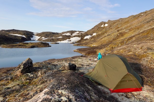
One thing to keep in mind is that the winds can get very strong and there are no trees for a sheltered camping spot. It’s best to have a wind-resistant tunnel tent, but our not-so-wind-resistant Hubba Hubba NX 2 managed to survive.
South Greenland is just a bit south of the Arctic circle, so there is almost, but not quite, 24 hours of daylight in late spring and summer.
We used MeteoBlue and Wunderground as weather forecast apps, but they were of limited use since the weather is very local and unpredictable.
Polar bears
Polar bears are far less common in South Greenland than in other parts of Greenland, but they are sometimes around. They come from East Greenland to South Greenland on the ice pack following the seals, their food source. By the time the hiking seasons starts in late May to June the ice pack has melted and the polar bears are mostly gone. But there have been a few exceptional years where the ice pack lasted longer than normal and there were one or two polar bear sightings in May or even in June. Unlike North Greenland, where the locals always carry a rifle outside, the locals in South Greenland normally don’t carry rifles.
Polar bear sightings in South Greenland are a big exiting deal, even for the locals. If there is an polar bear, sighting it will be all over the radio and everyone will know about it. So, ask the locals about it and they will tell you if any bears were seen, and if so, where. When we were hiking, there was one single polar bear sighting near Narsaq, far away from where we were hiking. And here is a photo of an polar bear mother with two of her cubs crossing the water that we saw from the ferry on the way to Narsaq.

Transportation to and from the hikes
There are no roads between the different towns in South Greenland (or anywhere in Greenland for that matter). In South Greenland, you have to travel by ferry or if you have money to burn, by helicopter.
There are three companies in this region of South Greenland:
- Disko Line operates small boats (4 to 12 passengers) between many of the small towns. It has a fixed schedule with fixed stops.
- Blue Ice Explorer also has small boats and is more flexible. Depending on the weather, they may be able to stop at some places where Disko Line cannot stop (e.g. Sillisit farm). They finalize their schedule only a few days before departure depending on customer demand. You can also charter boats. The staff at Blue Ice Explorer (Claus, Alexander, Birgitte, and Sten) are super friendly and helpful. You can also purchase maps, gas containers, and freeze dried meals at the Blue offices in Narsarsuaq or Qaqortoq (call ahead to make sure they are open and have what you need).
- Arctic Umiaq Line operates big ferries for hundreds of people with sleeping berths or cabins in various price categories. Their ferry goes every week (every two weeks in the low season) and stops at all the major towns in Greenland. We used this ferry to get from Nuuk to Narsaq and enjoyed it very much – it is a great way to experience the majestic coastline of Greenland.
In all three cases it is essential to book tickets by phone or by website at least several days in advance, especially in the high season.

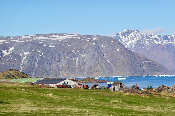
Sheep farms
If you plan to sleep in the accommodation or have a meal at one of the sheep farms, make sure to call ahead. In May and early June the farmers are extremely busy with the lambing season and may not have time to receive guests. And in late June through August the tourist season is at its peak and the farm may be fully booked.
The contact information is listed on the Blue Ice Explorer website.

Looks cool! I never thought about visiting Greenland but this looks excitinf. I’ve actually found your blog due to QKD content but then the travel posts caught my attention 😅 Was it very cold at night? The tent looks like a great idea but I am afraid it might be too cold for me there.
LikeLike
Hi Miriam. Glad to hear that you came for the QKD content but stayed for the hiking content. It is not as cold as you would imagine: in spring the temperatures in South Greenland are typically 10 to 15 Celsius during the day and 0 to 5 Celsius during the night. Very manageable with a good sleeping bag and sleeping pad.
LikeLike